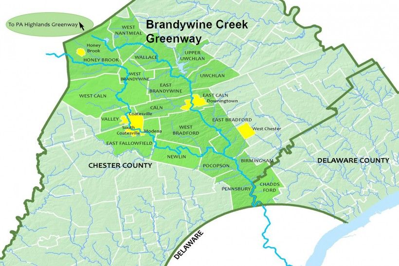
29 Municipalities, 40 Miles, 1 Greenway from Honey Brook, PA to Wilmington, DE.
Perhaps you’ve heard the term “greenway,” but are not quite sure what it means. In its broadest definition, a greenway is a corridor of protected public and private open space, managed for conservation and recreation purposes. The Brandywine Creek Greenway encompasses a 40-mile-long corridor of conservation lands that stretch from the Delaware state line just south of Chadds Ford to the Pennsylvania Highlands Mega-Greenway near Honey Brook.
The Brandywine Creek Greenway designation highlights the diverse resources of the Brandywine Creek corridor, provides conservation ideas and encouragement to municipalities and private land owners alike, and builds healthier, more sustainable communities that contribute to the well-being of those who live, work, and visit there. To learn more, visit www.brandywinegreenway.org.


Greenways align perfectly with our mission. Their purpose? To protect and improve water quality and vital natural resources. Promote recreational use of public lands. Preserve nationally and municipally designated historic and scenic resources for the benefit of future generations. Brandywine Conservancy helps municipalities recognize and take advantage of the many opportunities provided by greenway designation to protect these recreational, cultural, and natural resources.

Of course, successful implementation and management of a greenway requires cooperation at all levels — state, county, regional, municipal, and private — with municipalities taking the lead. The Brandywine Creek Greenway is a regional planning initiative of the 29 municipalities it encompasses and the Brandywine Conservancy's municipal assistance team, made possible with generous support from the William Penn Foundation, Pennsylvania’s Department of Conservation and Natural Resources, and Chester County.