Unionville Area Regional Comprehensive Plan

The Brandywine Conservancy recently helped the Unionville Area (made up of the municipalities of East Marlborough, West Marlborough, and Newlin Townships) update its Regional Comprehensive Plan—a document that helps guide a vision for future land use, growth, preservation, housing needs, and community facilities and services at the municipal level, which is meant to be updated every 10 years.
While many municipalities plan individually, there are advantages to planning with your neighbors. By planning cooperatively, municipalities can share the responsibility of providing for their fair share of development in areas that are best suited; consider preservation efforts at greater geographic scales, and provide for the efficient and cost-effective provisions of facilities and services, including recreation and public safety.
The Unionville Area started to plan in this manner back in 2011. The recent update, partially funded through a Chester County Planning Commission Vision Partnership Program grant, was led by the Brandywine Conservancy’s Municipal Assistance Program, with assistance from Tom Comitta and Associates, a planning firm based in West Chester. The Brandywine Conservancy’s active involvement in the conservation and stewarding of thousands of acres within an area known as the King Ranch (which is centered in the Unionville Region), made the organization’s Municipal Assistance Program a suitable choice to complete this important planning project.
While led by Brandywine Conservancy staff, the Update was guided by a Task Force made up of the Regional Planning Commission, which consists of one member of the Board of Supervisors and one member of the Planning Commission from each participating municipality. In addition, the process was overseen by a staff member from the Chester County Planning Commission. Critical to developing the vision and goals of the Comprehensive Plan is the active involvement and input from residents and key stakeholders of the area, including the School District and local business owners. Input from these groups was obtained through a public survey, a Community Visioning Session held at the Unionville High School, individual and group interviews and discussions with stakeholders, and through a presence at the Unionville Community Fair.

Making a Plan
The Conservancy’s approach to the Comprehensive Plan was to focus on five key issues that are important for the Region: Open Space Priorities; Historical Resources; Guiding Growth; Coordinated Parks and Recreation; and Resiliency. These key issues are explored in more detail within the plan and a set of planning considerations, goals and strategies are proposed. Overall, the Plan provides a framework to ensure the Region stays much like we know it today, with a focus on preserving and stewarding our natural areas, ensuring our agricultural economy and producers are supported, that growth is constrained to the areas that can best support it (along the Route 1 corridor and at an appropriate scale within our villages), our historical resources are protected and appreciated, a suite of community services and facilities provide for and promote a healthy, active and connected community, and that our region’s natural and built environment is resilient and able to plan for, adapt, mitigate, and react to the impacts we experience from increasingly frequent extreme storm and other weather events.
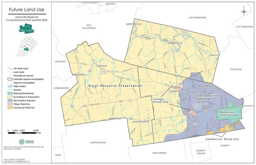
One critical element of the Plan is to define general regional land use, which is accomplished through what is known as a future land use map (see figure below). This map establishes a general policy guide for land use in the Unionville Region over the next 10-20 years. It provides a geographical vision for municipal policy and action as it pertains to land use, development, and preservation, helping to guide and shape the regulatory provisions of each Township’s Municipal Code (such as Zoning and Subdivision and Land Development Ordinances). As the map indicates, much of the Region is defined as Rural Resource Protection, where the expectation is for low-density, scattered rural homesteads, hamlets, and residential uses with discreet, small-scale, rural focused commercial activities. The next largest category is Site-Sensitive Suburban, which envisions residential uses with access to community facilities and where any future growth complements existing development and protects natural resources and the areas rural and historical heritage. Smaller areas depict land uses that are consistent with small-scale commercial enterprises, provide appropriately scaled housing, and that are connected and community focused within the villages of Unionville and Willowdale. Heavier commercial uses are constrained to the Route 1 corridor, and lands owned by Longwood are designated in support of the world-renowned botanical garden, recognizing the benefits they provide to the community, especially from the appropriate and continued stewardship of the natural areas that surround its core gardens.

After a two-year process, the Regional Comprehensive Plan was adopted at a Public Hearing on October 28th, 2024. Moving forward, the Comprehensive Plan represents a document to guide Township officials, administrative staff, and the various boards and commissions in each municipality in developing workplans and actions to implement the Plans overall goals. For more information on the Unionville Area Regional Comprehensive Plan, reach out to either the Township Manager for East Marlborough Township, or Rob Daniels, Manager of Community Services at the Brandywine Conservancy.